


Locus GIS Offline Land Survey
Locus GIS Offline Land Survey介绍
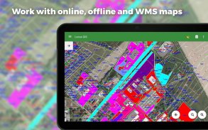
用于使用地理数据进行离线实地工作的专业 GIS 应用程序。它提供数据收集、查看和检查,并支持连接到外部 GNSS 单元,实现 NTRIP 客户端提供的厘米级精度。其所有功能均可在多种在线、离线和 WMS/WMTS 地图上使用。
实地考察
• 离线收集和更新现场数据
• 通过位置平均、投影、坐标和其他方法保存当前位置的点
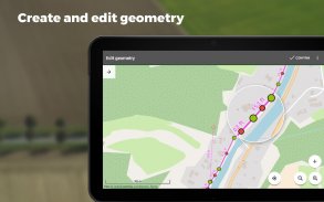
• 通过运动记录创建直线和多边形
• 属性设置
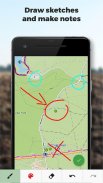
• 照片、视频/音频或绘图作为附件
• 设定出点
• 边界划分
• 收集位置数据以进行多边形/线记录或目标引导,即使应用程序在后台运行时也是如此
导入/导出
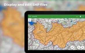
• 导入和编辑ESRI SHP 文件
• 将数据导出到ESRI SHP 或CSV 文件
• 将整个项目导出到QGIS
• 支持第三方云存储(Dropbox、Google Drive 和 OneDrive)
地图
• 广泛的地图可供在线使用和下载
• 支持WMS/WMTS 源
• 支持MBTiles、SQLite、MapsForge 格式的离线地图以及自定义OpenStreetMap 数据或地图主题
工具和功能
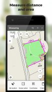
• 测量距离和面积
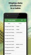
• 搜索和过滤属性表中的数据
• 样式编辑和文本标签
• 条件样式 - 基于图层的统一样式或依赖于属性值的基于规则的样式
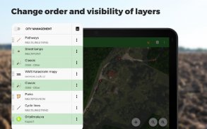
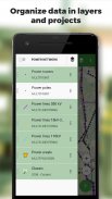
• 将数据组织到层和项目中
• 用于快速建立项目、其层和属性的模板
• 支持超过 4200 个全球和本地 CRS(例如 WGS84、ETRS89 Web Mercator、UTM...)
先进的 GNSS 支持
• 支持外部 GNSS 接收器进行高精度数据采集(Trimble、Emlid、Stonex、ArduSimple、South、TokNav...)以及其他支持蓝牙和 USB 连接的设备
• 星空图
• NTRIP 客户端和 RTK 校正
• GNSS 管理器,用于管理接收器以及设置杆高和天线相位中心
• 精度控制 - 设置最小公差以收集有效数据
表单字段类型
• 自动点编号
• 文本/数字
• 日期和时间
• 复选框(是/否)
• 具有预定义值的下拉选择
• GNSS 数据(卫星数量、HDOP、PDOP、VDOP、精度 HRMS、VRMS)
• 附件:照片、视频、音频、文件、草图、地图截图
Locus GIS 已成功应用于众多行业:
林业:
• 森林清查
• 树映射和检查
• 绘制物种组和植被图
环境
• 绘制植物和群落生境地图,呈现地图和区域划分
• 动物区系调查、环境影响评估、物种和栖息地监测
• 野生动物研究、植物研究、生物多样性监测
测量
• 搜索和查看边界标记
• 地形测量
• 地块测量
城市规划和测绘
• 更新公共工程部门的道路数据库
• 供水管道和排水系统的测绘和检查
• 绘制城市绿地和库存图
农业
• 农业项目和勘探自然资源,描述土壤特征
• 确定农业用地边界并确定地块编号、区域和所有权限制
其他使用方式
• 天然气和能源分配
• 风电场规划建设
• 矿区勘探和井位
• 道路建设和维护
Locus GIS Offline Land Survey - 版本1.23.10
(14-02-2025)Locus GIS Offline Land Survey - APK信息
APK版本: 1.23.10程序包: menion.android.locus.gisLocus GIS Offline Land Survey的最新版本
其他版本


同类应用
 4.324.34.07
 2.8
2.8


